
remote sensing

our work
kalteng remote sensing shows trends in environments like Kalimantan.
- TanDEM-X elevation model data for canopy height ...
- Monitoring Forest Threats with C- and L-band SAR, ...
- Ground Penetrating Radar Mapping of Peat ...
- Spectral Variability and Discrimination ...
- Kalteng Consultants Company Profile, Oct
- Visiting of Wetlands International Camp on ...
- Ortho Photo Mosaik von Kelurahan Tumbang Tahai ...
- Ortho-Photo Mosaik from Lake Batu, north of ...
- International Symposium & Workshop on Tropical ...
- The Contribution of CHRIS/PROBA Data for Tropical ...
- Workshop on Spatial Planning and new Remote ...
- Ortho-Photo Generation and Mosaiking of City ...
- Ortho-Photo Mosaik from Kecamatan Bukit Batu, ...
- International Workshop, Wild Fire and Carbon ...
- Planning Group for Kecamatan Bukit Batu gathered ...
- Carbon Storage in the Northern Sabangau Area ...
- Peat Land Topography derived from 30m Resolution ...
- Peat depth, minerals below peat, carbon, fires ...
- Carbon Storage in the Northern Sebangau Area ...
- Peatland Topography DEM-measurements with ...
- Precise Measurements of Peatland Topography and ...
- Environmental Management Study of the Tangkiling ...
- Environmental Field Trials and GIS Image ...
- Land Cover Change on Peatland in Kalimantan ...
- The Impact of Logging and Land Use Change in ...
- Tracks along the Kalimantan Highway from Kasongan ...
- Fires in 2002 monitored on the Landsat-images 14 ...
- The Amount of Carbon released from Peat and ...
- Land use Change in Central Kalimantan over the ...
- Remote Sensing and Aerial Survey of Vegetation ...
- Monitoring land cover and impacts, Remote Sensing ...
- Fire Impacts and Carbon Release on Tropical ...
- Ecological Impact of the one Million Hectare Rice ...
- Land Use Change and (Il)-Legal Logging in Central ...
- Peat fires in Central Kalimantan, Indonesia: Fire ...
- Environmental Helicopter Flight Trails with ...
- Impact of the 1997 Fires on the Peatlands of ...
- Application of Remote Sensing and GIS to monitor ...
- Monitoring of 1997/1998 Fires and Burnt Scars in ...
- Flight survey over the Mega Rice Project and over ...
- Application of Remote Sensing and GIS to survey ...
- Mega Rice Project in Central Kalimantan, ...
- Satellite Images and Aerial Photos from the ...
- The need for better
- Remote Sensing Verification by Aerial Surveys and ...
- NATURAL RESOURCE FUNCTIONS, BIODIVERSITY AND ...
- Excursion to Central Kalimantan, ...
- Satellite Images and Aerial Photography’s from ...
- Symposium of International Peat Society, ...
- Indonesia Travel to Jakarta, Bali and Kalimantan ...
- The Mega Rice Project Central Kalimantan ...
- Land Use Planning and Environmental Monitoring in ...
- Bildverarbeitung von Sensorbildern zur Erstellung ...
- GIS-Workshop, Camp km48 Sangai.
- Monitoring Land Use Change on Tropical Peatland ...
- Seminar on Scientific Implications of the ...
- Report of Ground Truth Campaigns incl. Aerial ...
- Ground and Helicopter verification of Satellite ...
- Environmental Detection from Satellite and ...
- First visit to Central Kalimantan in June 1995, ...
- Environmental Helicopter with Modular Sensor ...
- Remote Sensing with a Thermal Imager on an ...
- The Use of an Environmental Helicopter for the ...
- EUROMAR-SEASTARS a Modular Multi-Sensor System ...
gallery

image gallery
Find a large collection of images from many years of exploration by kalteng-consultants.
History Borneo - Kalimantan · Excursions to peatland 1996 · Mega Rice Project 1999 · 2004 · 2005 · 2006 · 2007 · 2008 · 2009 · 2010 · 2011 · 2012 · 2013 · 2014 · 2015 · 2016-March · 2016-August ·
remote sensing
Monitoring land cover and impacts, Remote Sensing (RS) and GIS used for Kalteng and Sarawak Borneo; STRAPEAT; 4-2002
STRAPEAT-workshop in Palangkaraya March 2002 and Sibu-Sarawak April 2002;
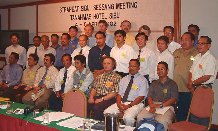
STRAPEAT-Team in Sibu, Sarawak, 5.4.2002

STRAPEAT-Team at CIMTROP-office, UNPAR, Palangkaraya
2002-Strapeat-Boehm-Siegert.pdf
First six monthly report .pdf
by
Dr. H.-D.V. Boehm, Dr. F. Siegert
Kalteng Consultants, Kirchstockacher Weg 2, 85635 Höhenkirchen near München,
Germany RSS GmbH, Wörthstraße 49, 81667 München
Tel.: +49-8102-774848, Fax.: +49-8102-774850
e-mail: viktorboehm@t-online.de
http://www.kalteng.org
e-mail: siegert@rssgmbh.de
Status of Remote Sensing and GIS For the STRAPEAT-Project, from 2002 to 2004, we have procured for analysis five Landsat images for Kalteng and Sarawak, in the time periode 1999 to 2000. New Landsat ETM images for the STRAPEAT-Project for Kalteng and Sarawak. 119/061 26.11.1999 all bands Kasongan 119/062
26.11.1999 all bands Sampit 120/058 31.08.2000 all bands Sibu on lower edge 120/059
31.08.2000 all bands Sibu on upper edge 121/059
18.05.2000 all bands Kuching In a second timeframe, approx. 2002 or 2003, we will analysis the difference of land use and vegetation changes in the peatland of Kalteng and Sarawak. The image shows several Landsat images from the Sarawak province, East-Malaysia.
