
remote sensing

our work
kalteng remote sensing shows trends in environments like Kalimantan.
- TanDEM-X elevation model data for canopy height ...
- Monitoring Forest Threats with C- and L-band SAR, ...
- Ground Penetrating Radar Mapping of Peat ...
- Spectral Variability and Discrimination ...
- Kalteng Consultants Company Profile, Oct
- Visiting of Wetlands International Camp on ...
- Ortho Photo Mosaik von Kelurahan Tumbang Tahai ...
- Ortho-Photo Mosaik from Lake Batu, north of ...
- International Symposium & Workshop on Tropical ...
- The Contribution of CHRIS/PROBA Data for Tropical ...
- Workshop on Spatial Planning and new Remote ...
- Ortho-Photo Generation and Mosaiking of City ...
- Ortho-Photo Mosaik from Kecamatan Bukit Batu, ...
- International Workshop, Wild Fire and Carbon ...
- Planning Group for Kecamatan Bukit Batu gathered ...
- Carbon Storage in the Northern Sabangau Area ...
- Peat Land Topography derived from 30m Resolution ...
- Peat depth, minerals below peat, carbon, fires ...
- Carbon Storage in the Northern Sebangau Area ...
- Peatland Topography DEM-measurements with ...
- Precise Measurements of Peatland Topography and ...
- Environmental Management Study of the Tangkiling ...
- Environmental Field Trials and GIS Image ...
- Land Cover Change on Peatland in Kalimantan ...
- The Impact of Logging and Land Use Change in ...
- Tracks along the Kalimantan Highway from Kasongan ...
- Fires in 2002 monitored on the Landsat-images 14 ...
- The Amount of Carbon released from Peat and ...
- Land use Change in Central Kalimantan over the ...
- Remote Sensing and Aerial Survey of Vegetation ...
- Monitoring land cover and impacts, Remote Sensing ...
- Fire Impacts and Carbon Release on Tropical ...
- Ecological Impact of the one Million Hectare Rice ...
- Land Use Change and (Il)-Legal Logging in Central ...
- Peat fires in Central Kalimantan, Indonesia: Fire ...
- Environmental Helicopter Flight Trails with ...
- Impact of the 1997 Fires on the Peatlands of ...
- Application of Remote Sensing and GIS to monitor ...
- Monitoring of 1997/1998 Fires and Burnt Scars in ...
- Flight survey over the Mega Rice Project and over ...
- Application of Remote Sensing and GIS to survey ...
- Mega Rice Project in Central Kalimantan, ...
- Satellite Images and Aerial Photos from the ...
- The need for better
- Remote Sensing Verification by Aerial Surveys and ...
- NATURAL RESOURCE FUNCTIONS, BIODIVERSITY AND ...
- Excursion to Central Kalimantan, ...
- Satellite Images and Aerial Photography’s from ...
- Symposium of International Peat Society, ...
- Indonesia Travel to Jakarta, Bali and Kalimantan ...
- The Mega Rice Project Central Kalimantan ...
- Land Use Planning and Environmental Monitoring in ...
- Bildverarbeitung von Sensorbildern zur Erstellung ...
- GIS-Workshop, Camp km48 Sangai.
- Monitoring Land Use Change on Tropical Peatland ...
- Seminar on Scientific Implications of the ...
- Report of Ground Truth Campaigns incl. Aerial ...
- Ground and Helicopter verification of Satellite ...
- Environmental Detection from Satellite and ...
- First visit to Central Kalimantan in June 1995, ...
- Environmental Helicopter with Modular Sensor ...
- Remote Sensing with a Thermal Imager on an ...
- The Use of an Environmental Helicopter for the ...
- EUROMAR-SEASTARS a Modular Multi-Sensor System ...
gallery

image gallery
Find a large collection of images from many years of exploration by kalteng-consultants.
History Borneo - Kalimantan · Excursions to peatland 1996 · Mega Rice Project 1999 · 2004 · 2005 · 2006 · 2007 · 2008 · 2009 · 2010 · 2011 · 2012 · 2013 · 2014 · 2015 · 2016-March · 2016-August ·
remote sensing
Environmental Field Trials and GIS Image Analysis’s in the Tangkiling District along River Rungan in Central Kalimantan, Indonesia, 9-2005
the International Symposium in Palangkaraya
21.- 24.09.2005
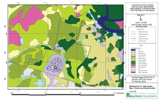
Land cover and zoning of Rungan Sari
by
*) Kalteng Consultants, Kirchstockacher Weg 2, D-85635 Hoehenkirchen, near Munich, Germany, Tel: +49-8102-774848, Fax: -774850 Email: viktorboehm@t-online.de,
**) Universidade Tecnologica de Pereira, Colombia, Carrera 3 No 20-65 p3, Pereira, Colombia, Tel: +57-6-333-2587
***) Jalan Tjilik Riwut km 36, No. 33, Rungan Sari, Sei Gohong, Palangkaraya, 73225, Central Kalimantan, Indonesia Boehm-Environmental field trials of Tangkiling District 22.09.2005
ABSTRACT
Landsat ETM images 118-61, 118-62, acquired on 14. Jan and 15. Feb 2003, were compared by using detailed analysis of the region around the Tangkiling granite hills and the black water river Rungan north of Palangkaraya. These images show major changes in this largest remnant of tropical peatland related to extreme rates of deforestation and the worst fires in 2002, since 1997, compared to older Landsat images from 1991, 1997, 2000, ref. 5+6. Ground truthing were done in this study area 2004 with a map-size of 26 km by 42 km in the Tangkiling district and around the hills itself of Sei Gohong and Rungan Sari in a small scale of approx. 12 km by 18 km with PSF, grassland, agriculture, scrub, riparian gallery, regrowth, secondary forest, home gardens, burnt areas from 2002, settlement, sand, water bodies etc.
The zoning areas were evaluated according to landscape ecological principles along river Rungan and along smaller rivers for development and conservation purposes. We did an environmental diagnosis for the zones under study, which classifies area of interest based on socio-cultural and economic aspects as well as ecological aspects. We formulate and prioritize strategies for the management of the areas trying to combine needs of conservation and local people necessities through alternatives of biodiversity utilization and land rehabilitation.
- Maps regarding the present environmental condition of the assigned areas will be presented in large and small scale around Tangkiling village (which describe and analyse the present situation)
- Zoning maps are produced for development and conservation areas regarding to three objectives based on the landscape ecological analysis: - Conservation of large preservation and restoration areas, such as high steep slopes, PSF, woodlands, green corridors, etc. - Conservation of small vegetation areas - Conservation of the vegetation along the river as a green corridor and water protection
- Areas in the small scale mapping around Tangkiling hills describe the current land cover such as agriculture, traditional home gardens, scrub and grass lands, forest and forest regrowth, housing and recreation areas, etc.
Keywords: Central-Kalimantan, Tropical Peatland + PSF, Conservation, Environmental Manage-ment, Zoning Areas, Peat-Fires 2002, Remote Sensing + GIS, GPS, Tangkiling, Sei Gohong, Rungan Sari.
