
remote sensing

our work
kalteng remote sensing shows trends in environments like Kalimantan.
- TanDEM-X elevation model data for canopy height ...
- Monitoring Forest Threats with C- and L-band SAR, ...
- Ground Penetrating Radar Mapping of Peat ...
- Spectral Variability and Discrimination ...
- Kalteng Consultants Company Profile, Oct
- Visiting of Wetlands International Camp on ...
- Ortho Photo Mosaik von Kelurahan Tumbang Tahai ...
- Ortho-Photo Mosaik from Lake Batu, north of ...
- International Symposium & Workshop on Tropical ...
- The Contribution of CHRIS/PROBA Data for Tropical ...
- Workshop on Spatial Planning and new Remote ...
- Ortho-Photo Generation and Mosaiking of City ...
- Ortho-Photo Mosaik from Kecamatan Bukit Batu, ...
- International Workshop, Wild Fire and Carbon ...
- Planning Group for Kecamatan Bukit Batu gathered ...
- Carbon Storage in the Northern Sabangau Area ...
- Peat Land Topography derived from 30m Resolution ...
- Peat depth, minerals below peat, carbon, fires ...
- Carbon Storage in the Northern Sebangau Area ...
- Peatland Topography DEM-measurements with ...
- Precise Measurements of Peatland Topography and ...
- Environmental Management Study of the Tangkiling ...
- Environmental Field Trials and GIS Image ...
- Land Cover Change on Peatland in Kalimantan ...
- The Impact of Logging and Land Use Change in ...
- Tracks along the Kalimantan Highway from Kasongan ...
- Fires in 2002 monitored on the Landsat-images 14 ...
- The Amount of Carbon released from Peat and ...
- Land use Change in Central Kalimantan over the ...
- Remote Sensing and Aerial Survey of Vegetation ...
- Monitoring land cover and impacts, Remote Sensing ...
- Fire Impacts and Carbon Release on Tropical ...
- Ecological Impact of the one Million Hectare Rice ...
- Land Use Change and (Il)-Legal Logging in Central ...
- Peat fires in Central Kalimantan, Indonesia: Fire ...
- Environmental Helicopter Flight Trails with ...
- Impact of the 1997 Fires on the Peatlands of ...
- Application of Remote Sensing and GIS to monitor ...
- Monitoring of 1997/1998 Fires and Burnt Scars in ...
- Flight survey over the Mega Rice Project and over ...
- Application of Remote Sensing and GIS to survey ...
- Mega Rice Project in Central Kalimantan, ...
- Satellite Images and Aerial Photos from the ...
- The need for better
- Remote Sensing Verification by Aerial Surveys and ...
- NATURAL RESOURCE FUNCTIONS, BIODIVERSITY AND ...
- Excursion to Central Kalimantan, ...
- Satellite Images and Aerial Photography’s from ...
- Symposium of International Peat Society, ...
- Indonesia Travel to Jakarta, Bali and Kalimantan ...
- The Mega Rice Project Central Kalimantan ...
- Land Use Planning and Environmental Monitoring in ...
- Bildverarbeitung von Sensorbildern zur Erstellung ...
- GIS-Workshop, Camp km48 Sangai.
- Monitoring Land Use Change on Tropical Peatland ...
- Seminar on Scientific Implications of the ...
- Report of Ground Truth Campaigns incl. Aerial ...
- Ground and Helicopter verification of Satellite ...
- Environmental Detection from Satellite and ...
- First visit to Central Kalimantan in June 1995, ...
- Environmental Helicopter with Modular Sensor ...
- Remote Sensing with a Thermal Imager on an ...
- The Use of an Environmental Helicopter for the ...
- EUROMAR-SEASTARS a Modular Multi-Sensor System ...
gallery

image gallery
Find a large collection of images from many years of exploration by kalteng-consultants.
History Borneo - Kalimantan · Excursions to peatland 1996 · Mega Rice Project 1999 · 2004 · 2005 · 2006 · 2007 · 2008 · 2009 · 2010 · 2011 · 2012 · 2013 · 2014 · 2015 · 2016-March · 2016-August ·
remote sensing
Monitoring of 1997/1998 Fires and Burnt Scars in Central Kalimantan, Indonesia for Along Track Scanning Radiometer (ATSR), 11-1999
ATSR-Report Abstract Central Kalimantan covers an area of 153,564 km² which is 28% of the total area of Kalimantan.
The southern part of the province consists of lowlands and wetlands (mostly peatland), constituting a total of 36,716 km² or 24% of the total extent of the province. This area comprises 812 km² of coastal plains, 12392 km² of alluvial plains (including floodplains), 1,027 km² of tidal swamps, and 22,485 km² of peat swamps (RePPProT, 1885).
The middle and northern belts of the land vary from low-altitude uplands to rolling hills with a height of up to 2,500 m (the Schwaner and Muller Mountains at the northern boundary). According to a 1995 statistics (Biro Pusat Statistik, 1996), Central Kalimantan has a total population of 1,627,000 and a population density of 11 per km² - very little compared to an average density of 101 per km² for the total of Indonesia. Up to the beginning of this decade it had huge pristine and (secondary) logged peatland areas which are changing quickly. Droughts, forest fires and famine were logical results.
In 1997, Central Kalimantan was one of three main regions in Indonesia where forests and peatlands were on fire.
The "Mega-Rice-Project" was a major location of "hot spots" because burning for land clearance had been started at the onset of the dry season. In June 1997, months before fires and smog had become a serious health hazard to millions of people in South-east Asia, the areas upstream of the reclamation project already suffered serious food shortages. A marked drop in the water-level of major rivers, combined with poor visibility due to smog hindered food transport, and lack of water for irrigation made the planting of crops impossible. By September/October 1997, famines were reported in the entire area.
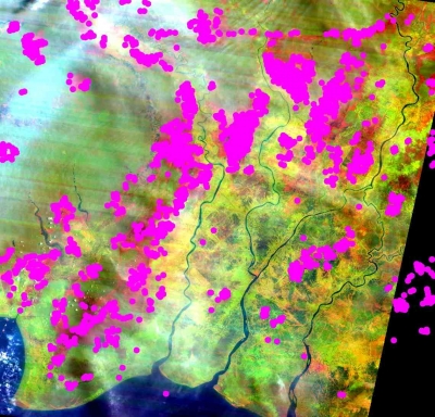
Hot Spots from 1997 in the Mega Rice Project Block A, B, C, D, E of Central Kalimantan
