
remote sensing

our work
kalteng remote sensing shows trends in environments like Kalimantan.
- TanDEM-X elevation model data for canopy height ...
- Monitoring Forest Threats with C- and L-band SAR, ...
- Ground Penetrating Radar Mapping of Peat ...
- Spectral Variability and Discrimination ...
- Kalteng Consultants Company Profile, Oct
- Visiting of Wetlands International Camp on ...
- Ortho Photo Mosaik von Kelurahan Tumbang Tahai ...
- Ortho-Photo Mosaik from Lake Batu, north of ...
- International Symposium & Workshop on Tropical ...
- The Contribution of CHRIS/PROBA Data for Tropical ...
- Workshop on Spatial Planning and new Remote ...
- Ortho-Photo Generation and Mosaiking of City ...
- Ortho-Photo Mosaik from Kecamatan Bukit Batu, ...
- International Workshop, Wild Fire and Carbon ...
- Planning Group for Kecamatan Bukit Batu gathered ...
- Carbon Storage in the Northern Sabangau Area ...
- Peat Land Topography derived from 30m Resolution ...
- Peat depth, minerals below peat, carbon, fires ...
- Carbon Storage in the Northern Sebangau Area ...
- Peatland Topography DEM-measurements with ...
- Precise Measurements of Peatland Topography and ...
- Environmental Management Study of the Tangkiling ...
- Environmental Field Trials and GIS Image ...
- Land Cover Change on Peatland in Kalimantan ...
- The Impact of Logging and Land Use Change in ...
- Tracks along the Kalimantan Highway from Kasongan ...
- Fires in 2002 monitored on the Landsat-images 14 ...
- The Amount of Carbon released from Peat and ...
- Land use Change in Central Kalimantan over the ...
- Remote Sensing and Aerial Survey of Vegetation ...
- Monitoring land cover and impacts, Remote Sensing ...
- Fire Impacts and Carbon Release on Tropical ...
- Ecological Impact of the one Million Hectare Rice ...
- Land Use Change and (Il)-Legal Logging in Central ...
- Peat fires in Central Kalimantan, Indonesia: Fire ...
- Environmental Helicopter Flight Trails with ...
- Impact of the 1997 Fires on the Peatlands of ...
- Application of Remote Sensing and GIS to monitor ...
- Monitoring of 1997/1998 Fires and Burnt Scars in ...
- Flight survey over the Mega Rice Project and over ...
- Application of Remote Sensing and GIS to survey ...
- Mega Rice Project in Central Kalimantan, ...
- Satellite Images and Aerial Photos from the ...
- The need for better
- Remote Sensing Verification by Aerial Surveys and ...
- NATURAL RESOURCE FUNCTIONS, BIODIVERSITY AND ...
- Excursion to Central Kalimantan, ...
- Satellite Images and Aerial Photography’s from ...
- Symposium of International Peat Society, ...
- Indonesia Travel to Jakarta, Bali and Kalimantan ...
- The Mega Rice Project Central Kalimantan ...
- Land Use Planning and Environmental Monitoring in ...
- Bildverarbeitung von Sensorbildern zur Erstellung ...
- GIS-Workshop, Camp km48 Sangai.
- Monitoring Land Use Change on Tropical Peatland ...
- Seminar on Scientific Implications of the ...
- Report of Ground Truth Campaigns incl. Aerial ...
- Ground and Helicopter verification of Satellite ...
- Environmental Detection from Satellite and ...
- First visit to Central Kalimantan in June 1995, ...
- Environmental Helicopter with Modular Sensor ...
- Remote Sensing with a Thermal Imager on an ...
- The Use of an Environmental Helicopter for the ...
- EUROMAR-SEASTARS a Modular Multi-Sensor System ...
gallery

image gallery
Find a large collection of images from many years of exploration by kalteng-consultants.
History Borneo - Kalimantan · Excursions to peatland 1996 · Mega Rice Project 1999 · 2004 · 2005 · 2006 · 2007 · 2008 · 2009 · 2010 · 2011 · 2012 · 2013 · 2014 · 2015 · 2016-March · 2016-August ·
remote sensing
The Use of an Environmental Helicopter for the Monitoring of Agro-Ecosystems; 4-1992
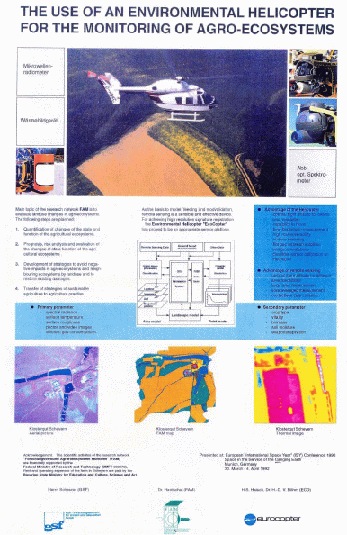 Poster for European 'International Space Year' (ISY)
Conference in Munich, Germany, April 1992
1992-THE_USE_OF_ENVVIRONM_HC_A3.pdf
by H.Scheurer 1), Dr.Hanschel 2), S.Haisch 3), Dr.Boehm 3)
1) GSF-Forschungszentrum für Umwelt und Gesundheit GmbH
2) FAM-Forschungsverbund Agrar-Ökosysteme Muenchen
3) ECD-Eurocopter Deutschland GmbH
Main topic a the research network FAM is to evaluate Landuse changes in agroecosystems. The following steps are planned:
- Quantification of changes of the state and function of the agricultural ecosystems.
- Prognosis, risk analysis and evaluation of the changes of state function of the agri-cultural ecosystems.
- Development of strategies to avoid negative impacts in agroecosystems and neighbourind ecosystems by landuse and to restore existing damages.
- Transfer of strategies of sustainable agriculture to agriculture practise. As the basis to model feeding and modvalidation, remote sensing is a sensible and effective device. For achieving high resolution signature registration the Environmental Helicopter "EcoCopter" has proved to be an appropriate sensor platform. Advantage of the Helicopter - optimal flight altitude for overall area resolution - capability to hover - time flexibility in mearurment - high maneuverability - surface sampling - fills gap between satellites and ground station - Satellite sensor calibration with helicopter sensorics Advantage of Remote Sensing - optmal flight altitude for different area resolution - large area measurements - area averaged measruement - contactless data collection Primary parameter - spectral radiance - surface temperature - surface roughness - photos and video images - different gas concentrations Secondary parameter - crop type - vitality - biomass - soil moisture - evapotranspiration
