
remote sensing

our work
kalteng remote sensing shows trends in environments like Kalimantan.
- TanDEM-X elevation model data for canopy height ...
- Monitoring Forest Threats with C- and L-band SAR, ...
- Ground Penetrating Radar Mapping of Peat ...
- Spectral Variability and Discrimination ...
- Kalteng Consultants Company Profile, Oct
- Visiting of Wetlands International Camp on ...
- Ortho Photo Mosaik von Kelurahan Tumbang Tahai ...
- Ortho-Photo Mosaik from Lake Batu, north of ...
- International Symposium & Workshop on Tropical ...
- The Contribution of CHRIS/PROBA Data for Tropical ...
- Workshop on Spatial Planning and new Remote ...
- Ortho-Photo Generation and Mosaiking of City ...
- Ortho-Photo Mosaik from Kecamatan Bukit Batu, ...
- International Workshop, Wild Fire and Carbon ...
- Planning Group for Kecamatan Bukit Batu gathered ...
- Carbon Storage in the Northern Sabangau Area ...
- Peat Land Topography derived from 30m Resolution ...
- Peat depth, minerals below peat, carbon, fires ...
- Carbon Storage in the Northern Sebangau Area ...
- Peatland Topography DEM-measurements with ...
- Precise Measurements of Peatland Topography and ...
- Environmental Management Study of the Tangkiling ...
- Environmental Field Trials and GIS Image ...
- Land Cover Change on Peatland in Kalimantan ...
- The Impact of Logging and Land Use Change in ...
- Tracks along the Kalimantan Highway from Kasongan ...
- Fires in 2002 monitored on the Landsat-images 14 ...
- The Amount of Carbon released from Peat and ...
- Land use Change in Central Kalimantan over the ...
- Remote Sensing and Aerial Survey of Vegetation ...
- Monitoring land cover and impacts, Remote Sensing ...
- Fire Impacts and Carbon Release on Tropical ...
- Ecological Impact of the one Million Hectare Rice ...
- Land Use Change and (Il)-Legal Logging in Central ...
- Peat fires in Central Kalimantan, Indonesia: Fire ...
- Environmental Helicopter Flight Trails with ...
- Impact of the 1997 Fires on the Peatlands of ...
- Application of Remote Sensing and GIS to monitor ...
- Monitoring of 1997/1998 Fires and Burnt Scars in ...
- Flight survey over the Mega Rice Project and over ...
- Application of Remote Sensing and GIS to survey ...
- Mega Rice Project in Central Kalimantan, ...
- Satellite Images and Aerial Photos from the ...
- The need for better
- Remote Sensing Verification by Aerial Surveys and ...
- NATURAL RESOURCE FUNCTIONS, BIODIVERSITY AND ...
- Excursion to Central Kalimantan, ...
- Satellite Images and Aerial Photography’s from ...
- Symposium of International Peat Society, ...
- Indonesia Travel to Jakarta, Bali and Kalimantan ...
- The Mega Rice Project Central Kalimantan ...
- Land Use Planning and Environmental Monitoring in ...
- Bildverarbeitung von Sensorbildern zur Erstellung ...
- GIS-Workshop, Camp km48 Sangai.
- Monitoring Land Use Change on Tropical Peatland ...
- Seminar on Scientific Implications of the ...
- Report of Ground Truth Campaigns incl. Aerial ...
- Ground and Helicopter verification of Satellite ...
- Environmental Detection from Satellite and ...
- First visit to Central Kalimantan in June 1995, ...
- Environmental Helicopter with Modular Sensor ...
- Remote Sensing with a Thermal Imager on an ...
- The Use of an Environmental Helicopter for the ...
- EUROMAR-SEASTARS a Modular Multi-Sensor System ...
gallery

image gallery
Find a large collection of images from many years of exploration by kalteng-consultants.
History Borneo - Kalimantan · Excursions to peatland 1996 · Mega Rice Project 1999 · 2004 · 2005 · 2006 · 2007 · 2008 · 2009 · 2010 · 2011 · 2012 · 2013 · 2014 · 2015 · 2016-March · 2016-August ·
remote sensing
Land use Change in Central Kalimantan over the Period 1991 - 2001 including Impacts of Selective and Illegal Logging, MRP Establishment and Fires, 9-2002
presented at
TROPEAT Symposium
in Bali, Kuta, arranged by JSPS,
(18. Sept 2002)
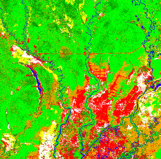
TREES-Classification of the area around Palangkaraya from the Landsat ETM image acquired 2000
kalteng_2002-43-TROPEAT-Land use ChangeinKalteng over the period 1991-2001.pdf
Land Use Change in Central Kalimantan over the Period 1991 - 2001 including Impacts of Selective and Illegal Logging, MRP Establishment and Fires. Abstract In Central Kalimantan grows on plain areas a lot of Peat Swamp Forest (PSF) from the coast at the Java Sea up to the north of the provincial capital Palangkaraya. PSF is among the earth's most endangered ecosystem. Peatland has a huge carbon storage capacity and is extremely fragile (Page et al. 2000 and 2002).
Local communities have used them extensively for centuries with no significant effect on the environment. This changed in 1995/1996 when a programme of massive peatland conversion, the so-called Mega Rice Project (MRP), was initiated with the aim of converting one million hectares of peatland into rice fields. Approx. 4000km of drainage and irrigation channels were constructed in the area designated for the MRP in two years (Notohadiprawiro 1998). Many people were able to access the previously inaccessible interior of this peatland landscape to exploit the residual timber resources, mostly doing this on illegal logging basis and using fire in the process. In summer 1997 deforestation was initiated by means of fire clearance as the most economical method. Enhanced by the El Niño Southern Oscillation (ENSO) in 1997, many of these fires set for land clearing spread into opened forest areas where they continued to burn with greater intensity. The detailed multi-temporal analysis of eight LANDSAT TM images acquired between 1991, 1994, 1996, 1997 (before the fires), 1998, 2000 (2x) and 2001 shows the quick change of the sensitive peatland and high rates of deforestation. Two TM images, 118-61 and 118-62, with 5.4 million ha were compared for 1991, 1997, 2000 and 2001. It was found by Remote Sensing (RS) and Geographical Information System (GIS) technology that from the TM 118-62 with approx. 2.4 Mha in 6/1991 1.560.377ha (64.8%) was covered with forest while in 5/1997 1.377.442ha (57.5%); res. 7/2000 1.110.151ha (45.7%) was covered with forest. Strong logging and illegal-logging took place (Boehm and Siegert, 2001).
Legal/selective logging operation prepared the ground for further degradation of the forests by fire, illegal logging and farming. More than 11,000km of logging railways were mapped in an area of 25,000km². Illegal logging could be often discriminated from selective logging operation in Landsat ETM images by its specific spatial pattern. The logged over area increased by 44% between 1997 and 2000. Field and aerial surveys showed that most of this increase could be attributed to illegal logging. Additionally land use changes as shifting cultivation mosaics, dry and swamp grassland, plantations, bushland, rivers and urban areas will be reported in the paper. The reduction of the forest between 1991 and 1997 is approx. 1.9% / year. Between 1997 and 2000 logging is increased for this three years of approx. 6.5% / year, this includes the fires in 1997, the illegal logging and the MRP activities.
As summery the deforestation between 1991 and 2001 is at average approx. 3.3% / year. If the situation continues as for the years 1991 to 2001 there is a very high risk that most of the PSF resource in Central Kalimantan will be destroyed within few years with grave consequences for the hydrology, local climate, biodiversity and livelihood of the local people. Unless land use policies are changed to control logging and the drainage of the peatland will be stopped recurrent fires will lead to an irrecoverable loss of this unique rainforest ecosystem, compare the last strong fires in 2002 (Boehm et al. 2003). The Spot-image shows the vegetation of Borneo: yellow and red colours are opened areas, different types of green colour describes the remaining forest and black colour are water bodies.
