projects
Our projects
Large areas of globally important tropical peatland in Southeast Asia are under threat from land clearance, degradation and fire jeopardising their natural functions as reservoirs of biodiversity, carbon stores and hydrological buffers. Local research capability will be strengthened enabling peatland managers to better understand and address the different, interrelated processes operating in tropical peatlands.
- Sambodja Lestari, BOS Foundation in ...
- LiDAR-Data and 30 RGB-Photos from Bukit ...
- RGB Photos from Block C and Sabangau catchment ...
- LiDAR survey 2011 in Central and East Kalimantan ...
- Three Ortho-Photo-Mosaiks taken with ...
- LiDAR and Ortho-Photo Survey in East- and Cenral ...
- LiDAR-Survey in Central Kalimantan for CKPP in ...
- EU - Project: RESTORPEAT-Project: Restoration of ...
- EU - Projekt: STRAPEAT-Seminar / Workshop on the ...
- EU Project - The STRAPEAT Project sponsored by ...
- EU Project: - Natural Resource Functions (Interim ...
- EU Project: - NATURAL RESOURCE FUNCTIONS, ...
- Mega Rice Project - The Benefits of Space-Based ...
- Mega Rice
gallery

image gallery
Find a large collection of images from many years of exploration by kalteng-consultants.
History Borneo - Kalimantan · Excursions to peatland 1996 · Mega Rice Project 1999 · 2004 · 2005 · 2006 · 2007 · 2008 · 2009 · 2010 · 2011 · 2012 · 2013 · 2014 · 2015 · 2016-March · 2016-August ·
projects
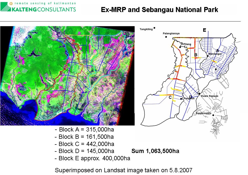
Mega Rice Project
 The development of wetlands for sawah rice cultivation is not new in Indonesia. Many decades ago coastal wetlands in Sumatra and Kalimantan were spontaneously opened and settled by Bugis people from South Sulawesi, Banjar people from South Kalimantan and Malay people from Riau, East Sumatra and West Kalimantan. They selected the better lands on the low, broad natural levees of big estuaries, avoiding carefully the too deep backswamps and peat soils. The tidal movement in the estuaries was spread laterally by simple networks of channels. By controlling the tidal movement the indigenous people succeeded in cultivating sawah rice, although on a modes scale of 1 - 2 km wide strip alongside estuaries. By present standards the yield was meagre of 0.8 - Mg/ha once a year. The Banjarese system became known as "sawah bayar",
The success of the Banjarese with their sawah bayar had attracted genuine interest of the Netherlands Indies government. The government built channels connecting big rivers as Barito, Kapuas and Kahayan, across their interfluves or common delta plains. The channels were also meant to provide waterways to improve the accessibility of the area and the big cities. The first Channel built in Kalimantan, named Anjir Serapat (anjir = Channel), was finished in 1890, connecting the rivers Kapuas and Barito spanning a distance of approx. 28 km .
A land-use conversion 1 Mio. ha (Mega-)-project for rice cultivation (including transmigration) started by the Indonesian government in January 1996. It is planned to develop an area of one million hectares in Central Kalimantan, situated between River Kahayan in the west and River Kapuas or River Barito in the east and Java Sea in the South. The total area of impact may be as much as 1 million hectares. It is proposed to use the remote sensing technology for all survey and planning tasks.
In order to undertake a global monitoring and survey in a short time it will be essential to use LANDSAT Thematic Mapper and ERS1/2 Radar images, linked to a programme of field checking of forest, peatland development and peat condition (including depth). A comprehensive literature survey must be carried out in order to assemble all published information, proceedings and institutional internal reports. All the data will be evaluated to prepare a detailed peatland analysis which will be stored in a Geographical Information System (GIS).
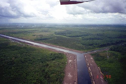
Mega Rice Project, Block A, New Channels and transmigration village in the back (3.8.1998)