
lidar technologies

Lidar technologies
We measure distances by illuminating a target with a laser and analyze the reflected light.
- Biomass Situation of Mawas Region in Central ...
- Spatial and temporal variation of above ground ...
- Multi-Temporal Airborne LiDAR-Survey and Field ...
- Relating ground field measurements in Indonesian ...
- Assessing Carbon Changes in Peat Swamp Forest ...
- Multi-Temporal Airborne LiDAR-Survey in 2007 and ...
- Characterizing Peat Swamp Forest Environments ...
- Multi-temporal Helicopter LIDAR- and RGB-Survey ...
- Application of LiDAR data for analyzing fires, ...
- LiDAR Technology for peatland using DSM- and ...
- Small-footprint airborne LiDAR technology for ...
- 2006 Fire depth and tree height analysis in Block ...
- Relating tree height variations to peat dome ...
- LiDAR- / Airborne Laser Scanning mapping of ...
- Rungan Sari PCB, Draft Masterplan with LiDAR-DTM ...
- LiDAR Survey of Small Scale Gold Mining near ...
- Airborne Laser Scanning measurements in Central ...
- Peatland Topography of Ex-MRP measured with ...
- Rungan Sari Airborne Laser Scanning 3D-Model and ...
- Peat Dome Measurements in Tropical Peatlands of ...
- Erfolgreiches Pilotprojekt im tropischen ...
- Airborne Laser Scanning monitoring of Ex-MRP area ...
- Successful Helicopter Flight Trials with Airborne ...
- Successful Helicopter Flight Trials with Airborne ...
- OK Osaki Tsuji Boehm, Liesenberg- Appraisal of ...
gallery

image gallery
Find a large collection of images from many years of exploration by kalteng-consultants.
History Borneo - Kalimantan · Excursions to peatland 1996 · Mega Rice Project 1999 · 2004 · 2005 · 2006 · 2007 · 2008 · 2009 · 2010 · 2011 · 2012 · 2013 · 2014 · 2015 · 2016-March · 2016-August ·
lidar-technology
2006 Fire depth and tree height analysis in Block C, Central Kalimantan, using small-footprint airborne LiDAR data; 9-2010
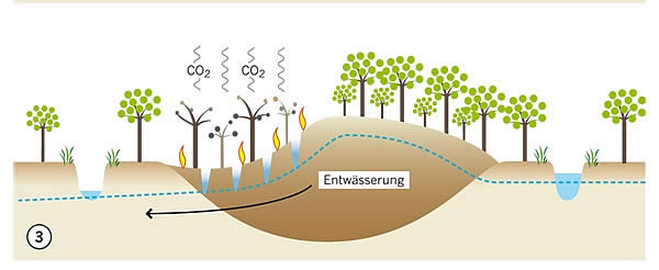
Peat fires and drainage of peat dome Source WWF 2009
Wildfire-Boehm-Liesenberg-Frank-Limin-5.1.2011.pdf
Kalteng_2010-Boehm_et.al_Wild Fire Workshop 28.9.PKY, Indonesia.pdf
Wildfire-Boehm-Liesenberg-Frank-Limin-5.1.2011.pdf
Kalteng_2010-Boehm_et.al_Wild Fire Workshop 28.9.PKY, Indonesia.pdf
2nd International Workshop on "Wild Fire and Carbon Management in Peat-Forest in Indonesia"
28th-29th September 2010, Palangka Raya, Indonesia
by
by
Hans-Dieter Viktor Boehm 1.), Veraldo Liesenberg 2.), Suwido H. Limin 3.) and Juergen Frank 1.)
1.) Kalteng Consultants, Kirchstockacher Weg 2, D-85635 Hoehenkirchen, Germany
Tel:+49-8102-774848, viktorboehm@t-online.de; www.kalteng.org
2.) Freiberg University of Mining and Technology, Germany, veraldo@gmail.com
3.) University Palangka Raya, CIMTROP, Central Kalimantan, Indonesia
Abstract
Natural tropical Peat Swamp Forests (PSF) are important for their rich biodiversity and because they represent important carbon pool. However, PSF are decreasing due to conversion into farm land, by excessive draining, the use of shifting cultivation on a large scale, illegal logging and peat fire. This increases the interest for mapping such environments as they are recognized as an important source of carbon released into the atmosphere. Airborne laser scanning has the ability to measure the vertical and horizontal structure of forest vegetation. The aim of this study is to demonstrate how measures derived from small footprint airborne light detection and ranging (LiDAR) data can be used to investigate the relationships between tree height represented by the digital surface model (DSM) and the difference to the digital terrain model (DTM).to estimate the above-ground biomass (AGB). The peat fires of 2006 were analyzed too and the dependence of Tree height and peat slope. The test site is a typical PSF landscape located in Central Kalimantan, Indonesia near the province capital Palangka Raya. In August 2007 we mapped by helicopter different PSF locations with Riegl LiDAR Technology LMS-Q560 in the Block C of the Ex-Mega Rice Project (EMRP) and in the Sabangau National Park Cimtrop transect. In each LiDAR transect we tested different sample plots sizes in relative undisturbed areas ranging from 50x50m to 100x100m along the flown acquisition in a minimum distance of 200m each one. In the fire determination we only account for the lowest values of the DTM in order to minimize the inclusion of the return signal coming from tree trunks and branches lying on top of the peat surface. The DTM backscatter in PSF through the canopy was 1% - 3% of the total Laser beams. We adopted a similar procedure for the DSM where we account just the signal coming from the tree canopies. During the data analysis linear and non-linear regression functions were then used to predict the relationship between tree heights and peat slope.
Results showed that the ABG regression analysis of the 100mx100m samples measured parallel to the Turana channel ranged from 85 to 390 Mg/ha which has to be verified by field analysis. The PSF tree height of the Cimtrop transect increases by approx. 5m when the Peat Dome Slope increases from 0.5 pro mille to 1.5 pro mille from Sabangau River to the peat dome. The 2006 fires on the two areas in Block C showed a fire depth varying from 15cm to 30cm. An extrapolation of the fire damages was done using ancillary Landsat scenes of 2007 to the entire Block C and approx. 150 Mio ton of C were release to the atmosphere in 2006. This LiDAR-methodology can be used in the frame of the REDD knowledge of tropical forests (Reducing Emissions from Deforestation and forest Degradation).
Keywords: Peat Swamp Forest, LiDAR, ALS, DSM, DTM, Kalimantan, AGB, REDD, EMRP
