
lidar technologies

Lidar technologies
We measure distances by illuminating a target with a laser and analyze the reflected light.
- Biomass Situation of Mawas Region in Central ...
- Spatial and temporal variation of above ground ...
- Multi-Temporal Airborne LiDAR-Survey and Field ...
- Relating ground field measurements in Indonesian ...
- Assessing Carbon Changes in Peat Swamp Forest ...
- Multi-Temporal Airborne LiDAR-Survey in 2007 and ...
- Characterizing Peat Swamp Forest Environments ...
- Multi-temporal Helicopter LIDAR- and RGB-Survey ...
- Application of LiDAR data for analyzing fires, ...
- LiDAR Technology for peatland using DSM- and ...
- Small-footprint airborne LiDAR technology for ...
- 2006 Fire depth and tree height analysis in Block ...
- Relating tree height variations to peat dome ...
- LiDAR- / Airborne Laser Scanning mapping of ...
- Rungan Sari PCB, Draft Masterplan with LiDAR-DTM ...
- LiDAR Survey of Small Scale Gold Mining near ...
- Airborne Laser Scanning measurements in Central ...
- Peatland Topography of Ex-MRP measured with ...
- Rungan Sari Airborne Laser Scanning 3D-Model and ...
- Peat Dome Measurements in Tropical Peatlands of ...
- Erfolgreiches Pilotprojekt im tropischen ...
- Airborne Laser Scanning monitoring of Ex-MRP area ...
- Successful Helicopter Flight Trials with Airborne ...
- Successful Helicopter Flight Trials with Airborne ...
- OK Osaki Tsuji Boehm, Liesenberg- Appraisal of ...
gallery

image gallery
Find a large collection of images from many years of exploration by kalteng-consultants.
History Borneo - Kalimantan · Excursions to peatland 1996 · Mega Rice Project 1999 · 2004 · 2005 · 2006 · 2007 · 2008 · 2009 · 2010 · 2011 · 2012 · 2013 · 2014 · 2015 · 2016-March · 2016-August ·
lidar-technology
Multi-temporal Helicopter LIDAR- and RGB-Survey in August 2007 and 2011 over Central Kalimantan´s Peatland, Sept.2011
by
Boehm, H.-D.V., Liesenberg, V., Frank, J. and Limin,S.
presented during the 3rd International Workshop on "Wild Fire and Carbon Management in Peat-Forest in Indonesia", Palangka Raya, Indonesia, 22-24 September 2011
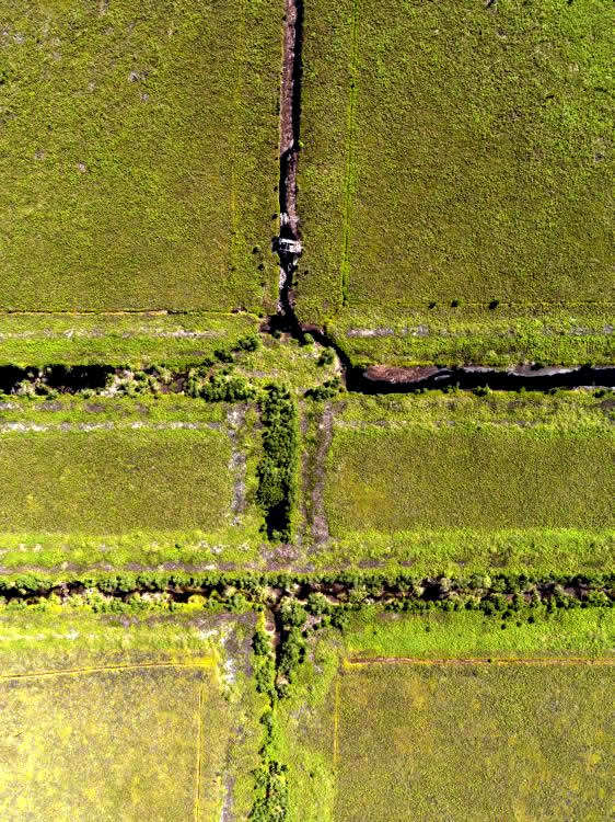
Ortho-Photo from Main Channel crossing with the North-South Channel, 6. August 2011
In August 2007 and 2011 we mapped by helicopter different PSF transactions with Riegl LiDAR Technology (LMS-Q560) in Central Kalimantan, Indonesia. In this study, our main objectives were: a) to describe our activities during the multi-temporal LiDAR survey; b) to evaluate the peat swamp forest resilience with multi-temporal LiDAR observation; and c) to demonstrate our future activities concerning to the applicability of LiDAR technology in different environmental applications. Additionally, we demonstrate first results of our second LIDAR survey made in August 2011. We found by multi-temporal LiDAR approach that in an undisturbed tropical PSF area the average tree-height increased from 15.32m to 17.18m by difference of 1.86m which is 12%. The presented LiDAR-methodology can be promising in the frame of the REDD+ (Reducing Emissions from Deforestation and forest Degradation) knowledge of tropical peat swamp forests. The LiDAR technology supports the MRV aspect of REDD+ (Monitoring, Reporting, and Verification).
Keywords: Peat Swamp Forest, LiDAR, ALS, REDD and EMRP.
